
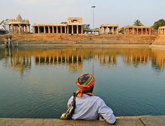
The popular image of any historical cultural landscape is constructed by actors with bestowed interests. These actors when possessed with power, envisage their intentions through tangible or intangible manifestations. Writing from varied cultural and political contexts of time along with religious scriptures on the landscape becomes one of the prominent tools of image production. This constructed image of the landscape is further reinforced by varied means such as movies, travelogues, mass media and other visual media. These means nurture the image produced, till it is established as an entrenched image of place, eventually leading to habituation of the portrayed image.
Though this popular image production enhances a few chosen elements of landscape, it often leads to neglect and degradation of others. To the local habitants the lived experience of a place is totally varied, if not contradictory, to the popular image portrayed by visitors. This means of habituation of selected elements is fostered by the visitors to a place. Another means of habituation of landscape is common amongst the inhabitants through lived experience of the place. As the transparent layers are smeared opaque with time, these two forms of habituation eventually lead to discontinuity of associated patterns between natural, social and religious layers forming the imagined landscape. This process of transition in landscape happens gradually enough, for locals to comprehend changes leading to the popular image becoming unanimous.
Case in point being the historic settlement of Melukote, Karnataka, in southern India, which is in synergy with varied elements of landscape encompassing a thousand years. Melukote is located in the Padavapaura taluka (administrative area) of the Mandya District of Karnataka. It is about 51 km from Mysore and 133 km from Bengaluru. The name ‘Melukote’ is derived from the meaning of a fort on top of the hill and the place is spread over an area of about 15 sq. kms and at an elevation of 150 m from the surrounding plains. ‘Melu’ means Upper and ‘Kote’ means Fort, in the vernacular language Kannada. As per a 1991 census, Melukote Mandal Panchayat with an area of 4.28 sq. km had a total population of 3,254, which after two decades has almost doubled.
The entry of a settlement hill on all eight cardinal directions is marked with the shrine of Hanuman: the God of protection, and is situated alongside the stone pathway up the hill. These shrines, which are still revered by the local community, are painted in white with ochre red stripes signifying their sacredness.
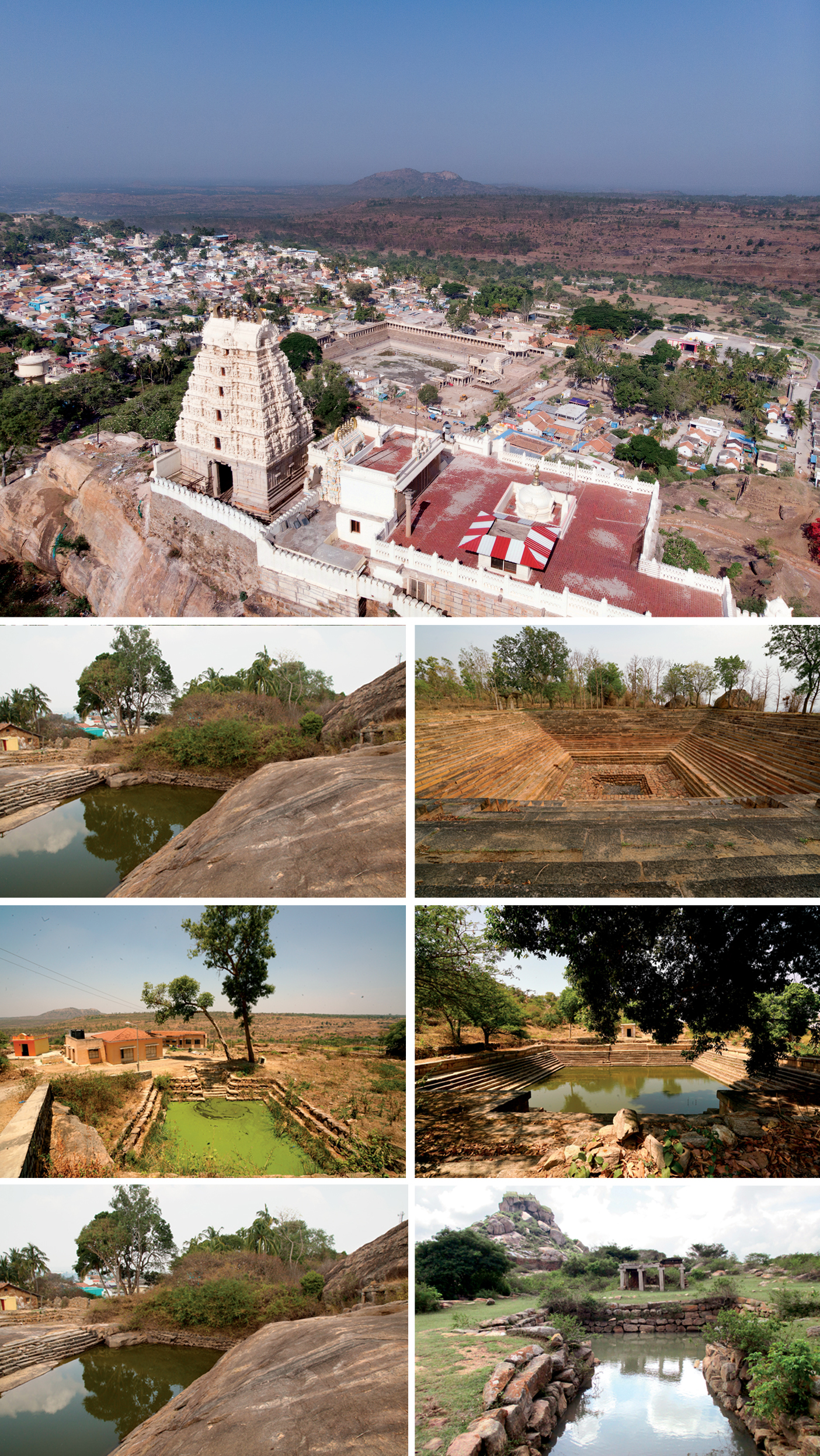
Second Row - Left & Right: Hosa Bhavi, Shingarayyangar Kola
Third Row - Left & Right: Palasha Theertha Kola, Ulli Bhavi
Fourth Row - Left & Right: Chotthi Kola. One of the 135 tanks documented.
The origin of the main temple, marking the spline of the settlement with the idol of Chelluva Narayanaswamy, dates back to the legend that Lord Narayana was already present before Ramanuja’s arrival in Melukote. Ramanuja had to flee from the Chola Kingdom and take refuge in Karnataka under the Hoysala King Visnuvardhana, who had converted from Jainism to Vaishnavism. Inscriptions support the conversion of many villages into agrahara (grant of land and royal income from it) by the converted King Visnuvardhana. After renovating Melukote, Ramanujacharya designed a system for performance of religious rituals of varied order, which continues even today. The system was ensured sustenance by establishment of different matas. About 150 years ago, 200 Vedic scholars are said to have resided here; very few scholars of the tradition remain till date. Associated rituals at varied scales from storytelling in a household to circumambulation of specific tanks around the settlement is studied through documentation and discussions with people. These rituals evolve over time assigning new meanings to the dynamic landscape.
Water architecture – one such associated pattern amongst many others – is chosen as a case of inquiry. The tanks, ponds, lakes in and around the settlement are studied using mapping and photo documentation in order to understand the hydrological functioning of the system, selection of particular location in topography, functions associated with each pond, conditions for transformation of a tank into a tirtha (holy crossing or place) and patterns amongst these tirtha. Even the flight of steps to go down to the pond is built following the flow of water. The tanks are of different shapes and sizes, but mostly built according to the traditional texts. The construction technology of these tanks is unique; there is no mortar used for joining of stones, they are corbelled to allow percolation of water. The taste of water varies in each pond.
To the local habitants the lived experience of a place is totally varied, if not contradictory, to the popular image portrayed by visitors
The divine is said to have manifested dotting the landscape with 108 tanks. However, this is believed to be a popular myth with most people aware of only ten tanks. Every tank has a story and every story has a tank associated with it. While Melukote is not a unique case in terms of a natural water harvesting system of medieval fortified towns, the continuing threads of ritual practices over the past 600 years have produced an intentionally woven and intrinsically imagined landscape. However, both the imagination and intentions are fading off the landscape leading to fragmentation of the woven patterns. Unmindful construction activities to accommodate the ever-growing floating population has led to defragmentation of patterns. They still have potential to be immediately acted upon.
The state of Karnataka is the second largest area of dry land in the country. The average rainfall is 690 mm, but as most of the terrain is undulating it has the second lowest replenishable ground water resource. The historic settlement of Melukote, with its altitude, had to conserve rain water for sustenance of the inhabitants. Thus the landscape is dotted with tanks and ponds that were designed in accordance with the topography of the place. The natural hydrology of settlement works mainly on open drains along the street edges and sheet flow of water. The open drains have become dump yards and new drainage lines are being merged with water lines polluting the ponds. Water moving along the surface through sheet flow takes a long time to reach a critical velocity or volume.
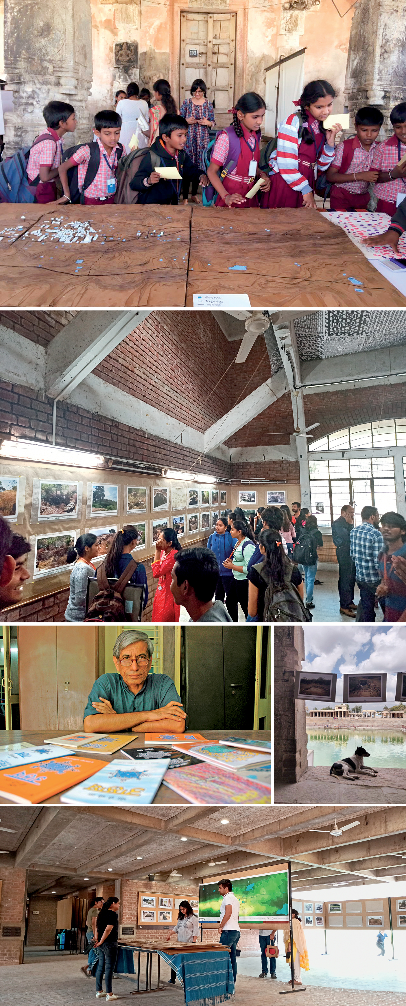
Second row: Students at the exhibition
Third row - Left: Anupam Mishra
Third row - Right: : Exhibition display near the pond at Melukote
Bottom: Exhibition at CEPT
As a result, groundwater recharge and storage has increased due to maximum infiltration and reduction in pollutants. The sheet flow of water from the catchment area drains into agricultural land, which is stored using check dams or farm ponds, and is used for irrigation. The farmers downstream are affected and resort to bore wells, which in turn leads to depletion of the ground-water levels leading to the wells and ponds being devoid of water. While most of the tanks are physically intact, the hydrological connections have been lost over the years. However, the rituals that are associated with different cycles of nature continue to be celebrated glorifying the system. While certain rituals have been degraded and have depleted the landscape, there is legible change in patterns of continuing rituals. Construction of new apartments/guest houses to accommodate the increasing floating population could be observed along the main spline, towards the ridge of the hill encroaching upon catchment areas. This indirectly affects the vernacular architecture and their immediate cultural and social associations. In the long term, this affects the natural hydrological system of the landscape. The water architecture – the spline of settlement encompassing varied actors and functions – is thus in dire need of some form of action.
Living landscapes exhibit archetypical cyclic patterns of behaviour of one cause leading to another. The leverage of this vicious cycle lies in the actors breaking out of their bounded rationale behind their roles in the landscape. However, this could be accomplished only by letting go of narrow goals and considering the long term welfare of the entire landscape. In order to bring about this realisation to the actors of a landscape, an outsider’s perspective becomes inevitable. The subconscious process of habituation happens on varied scales, from household objects to a community ritual of the settlement. One instance of such habituation of elements is the percussion instrument inherited by the community of ‘Dasaya’ who have been filling the kalyani with their music for centuries. This ritual and its relationship to the landscape is unique and might have been qualified as a myth, if not for inheritance by the community. Other instances of habituated built environment are the ‘Rayagopura’ the southern entrance gateway of the town and ‘Panch Kalyani’, which have been repeatedly showcased in many movies.
Unmindful construction activities to accommodate the ever-growing floating population has led to defragmentation of patterns
‘Defamiliarisation’, a tool of literature and arts, is employed as a means to understand the perception of local people to their habituated landscape. The outcome of this process is pitched along with research findings of this intricate water system in an attempt to enhance the perception of the locals. Though the locals know their landscape better, an outsider who is not habituated to it can educate and exhort to help people see the consequences of unrestrained use of commons. This self-driven change in perception of their habituated landscape will lead to conservation without adverbs.
Children from primary and middle school from Boys High School and Girls High School, Melukote, were asked to sketch without any given/implied restrictions:
• What comes to their mind when they think of Melukote?
• Wayfinding map of all kolas (tanks) they have visited in Melukote
Interestingly, out of 200 samples (sketches) collected, more than a 100 samples had sketches of tanks in them, while other children had opted to draw their houses, cows, goats, betta (hillock) and so on. However, children were aware of only Panch Kalyani, Akka Thangai Kula, and Dalavayi Kere, which are the popular images portrayed through varied visual means. While some children were happy sketching with plastic rulers, others were scared whether these sketches would be given for grading. While this inference is from analysis of experiments with children, the same will hold true across varied age groups. There are four men who are above the age of 70 who are potential sources of ‘Oral History’ of place and remember the vague location and number of kolas that have vanished from the landscape.
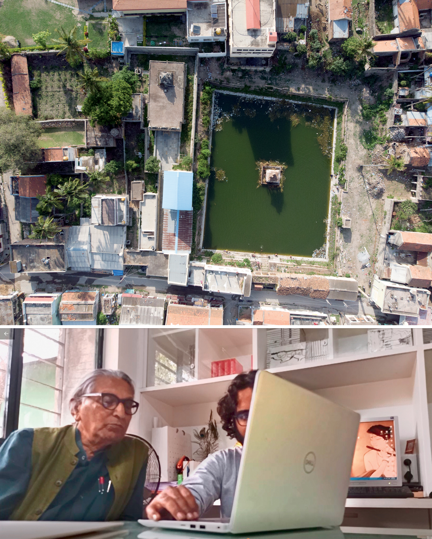
Bottom: Presentation with Pritzker Prize-Winner Architect B. V. Doshi
The location of the existing tanks were discovered after hunting for six months and were mapped onto the topographical map with photo documentation of each. There are 134 water structures documented, out of which six have been covered up and buildings built over. This number exceeds the mythological figure of 108, as natural springs and ponds were also considered. However, recent construction of farm ponds are not taken into account. This shows that 108 is not a mere mythological number as popularly believed. Having established this, the popular perceived notion had to be defamiliarised.
In 2015, a moving exhibition of the findings of the location of 108 tanks was juxtaposed along with the 200 sketches done by school children. An exhibition was held at two prominent nodes: One next to Janapada Seva Trust, at the junction of streets with visitors to Kalyani and locals living up in the hills. Another at Puthina Kala Mandira along with school children as part of a summer camp. The reactions from locals and children were not as expected as most were not used to reading maps. Hence they were interested in the pictures to locate in their memory scape of the landscape. This kind of exhibition at a public space was a first for Melukote. This was an initial step towards bringing about an enhancement in their perception of the landscape. A poem was composed and translated into the local language (Kannada), which was intended as a wakeup call to the local people to enhance their perception about their habituated landscape.
‘Namma Ooru Namma Kola’ is an attempt to recreate a sense of association and cultivate social responsibility among the local people, to preserve their 1000-year-old traditional water system in Melukote, Karnataka. This was a traveling exhibition designed and curated in 2020 by Akarmaa Foundation and supported by the Doshi We Know Fellowship. The exhibition has been hosted across different universities all over India. The objective of the exhibition is to create awareness about traditional water systems across India. It was dedicated to Shri Anupam Mishra, pioneer of community centric water conservation in India.
Further to this exhibition, as a pilot project, one of the tanks in the settlement - ‘Choti Kola’ and the adjoining mandapa (pavilion) were proposed to be revived based on the ‘Integrated Community Centric’ approach of conservation.
(If you would like to support, donate, volunteer for the project please do write to us at akarmaafoundation@gmail.com)
All photos: Cuckoo Forest School

Comments (0)